Warruming the Bungles of your heart (?)
This is the first part of the report of a trip to the Pilliga area, just North of Coonabarabran, which is the gateway to the Warrumbungle National Park. This was part of our "visit every town in NSW" campaign, although few towns were expected to be visited. It was also hoped that I'd get some less common (in Carwoola) birds of the day.
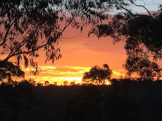
The day of departure was a tad cool, but with a very nice sunrise.
 The drive was basically a drive. I had decided to watch for election posters along the
way. As we were going through core Nationals
country I expected to see a lot of their stuff.
In fact the only 2016 poster I saw – just out of Yass - was one for Mike
Kelly, our local ALP candidate. At the end of the trip, going in
to Pilliga Pottery I saw a reference to Greens in New England – I'd thought we
were a fair bit West of that electroate.
The drive was basically a drive. I had decided to watch for election posters along the
way. As we were going through core Nationals
country I expected to see a lot of their stuff.
In fact the only 2016 poster I saw – just out of Yass - was one for Mike
Kelly, our local ALP candidate. At the end of the trip, going in
to Pilliga Pottery I saw a reference to Greens in New England – I'd thought we
were a fair bit West of that electroate.

 Here is a close up!
 Going through the Goonoo State Forest we saw signes warning about Malleefowl. I was not hopeful of encountering one and Frances did ask if the signs were painted - a reference to birds with 'painted in their name being pigments of the imagination (an Ian Fraser comment). While the signs were not illusory the birds were. Emerging from the forest we got to Mendooran which to our surprise had a large campground full of big 'vans. This must be something to do with fishing on the Castlereagh River. We didn't stop in the town this time - see next post for that.
So we got to Coonabarabran and headed out North - as the road signs had improved since about 1988 we found the turnoff to the Newell Highway this time - to the Pilliga Pottery where we intended to camp. I had spoken to them so knew that they only had unpowered sites. They did have fire circles and thanks to Frances we'd taken along some firewood to save having to gather it. Here it is in action
 You will gather from Frances' attire that it wasn't very Warrum.
 In fact it was bloody cold. The next morning the car thermometer read 1oC at 7am and the fire was re-lit to have breakfast in comfort. We then went out on a walk around the surrounding farm. In one of her art classes Frances had been made aware of the incidence of natural objects having patterns that could be described by the Fibonacci sequence. So we were looking for examples of this and found an object that might do so.
It is clear what class of object it was, but which species had dropped it?
 Later in the day, at the Pilliga Discovery Centre, Frances found an example in a disply cabinet: it is evidence of Emu.
The area close to the pottery was well endowed with old broken down farm equipment. I don't think they have ever disposed of anything: the spokes and rim of an old wooden wagon wheel suggest this trove has been in development for some time.
 A lot of creative pottery was in the gardens around the buildings. This ceramic tree was the highlight.

 Getting a little out of chronological sequence, at night the 'pods' turned out to have small lights in them. This shot was with flash ...
 .. and this one without.
 Getting back to the timeline our business on the first full day was to go to Barradine on the Western side of the Pilliga and follow some bird routes. After enquiring about the state of the roads that went from the Newell in that direction I was told that No. 1 Break Rd (or as it appeared on the signs No One Break Rd) was in good shape, but 'a bit sandy'. So we went that way. A fire had been through.
 As it was on both sides of the road I assume this was a wildfire not controlled burn paradise.
 A mirror image shows the rooster tail behind the car.
 It was certainly sandy. I didn't have to use 4WD or deflate tyres to get through but at times was distinctly heavy going. I found this the worst road we encountered on the trip: it seems that the locals judge the quality of the road solely by the level of corrugation (which was quite low on this road).
On getting to Barradine we found the memorial. This wasn't in the Register of NSW War Memorials so will get added.
 Outside the Discovery Centre was a amusing emu sculpture! Obviously a male adult with chick.
 Heading off on the expedition we got to Kenebri. This didn't have a war memorial or indeed much of anything, This house was a tad below the average, but only a tad,
 Bird life was not greatly evident. This is not a great surprise as we were there in the middle of the day and there was very little blossom. This collection of aloes were a surprise, but were on the site of The Aloes homestead on a run taken up in the 1860s.
 At our next stop (Rocky Creek picnic area) there were quite a few small birds around including Speckled Warblers, Inland Thornbill, Jacky Winter and Eastern Yellow Robin. The last were a surprise in such a dry area. There were also a few flowers (no idea what).
 We headed back across the top of Timballie National Park (not entering because of dog) and out virtue was rewarded when we encountered a Ranger - who seemed as surprised to see us as we were him. We came across this small dam which is apparently a watering place for Glossy Black Cockatoos (but not when we were there). We thought that this would be popular with witches as it wouldn't be deep enough to drown in when dunked! So the concept of a Witch Pond has entered our life!
 A very nice Lookout Tower has been built at the Salt Caves. It is a little challenging to climb as the stairs are see-through and it it is quite high!
 I made it about 2/3 of the way up and decided that I didn't need to go higher to see the Warrumbungles in the distance to the South ...
 .. or the mind-blowing flatness in every other direction.
 We travelled back across Burma Rd which was a bit narrower than No 1 Break but not as sandy .
By the time we got to the camp it was already quite brisk and after a pleasant tea we piled into bed. I was soon asleep so missed a burst of gunfire, which - when Frances mentioned it the next day I assumed was pig improvement.
The day of departure was a tad cool, but with a very nice sunrise.

Once past Boorowa we commented on how green everywhere
was. They have obviously got a good drop
recently. Most of the rest of the
country looked to have been seeded, and we didn't see anyone sowing until we
got to We1lington.
We did a small explore of the settlement of Geurie but couldn't find a war memorial so on to Dubbo. That was basically a large town but we found our way through and out on the road to Gilgandra. To my surprise the distance to Connabarabran on road signs appeared to be 30km more than I was expecting. That seemed to be because the distances were taken through Gilgandra, rather than turning off through Mendooran.

This was not a huge problem although trying to pick the right turnoff was tricky as Mendooran Rd was called something else where it turned off the highway. It did give us a chance to check out these sculptures however.


So we got to Coonabarabran and headed out North - as the road signs had improved since about 1988 we found the turnoff to the Newell Highway this time - to the Pilliga Pottery where we intended to camp. I had spoken to them so knew that they only had unpowered sites. They did have fire circles and thanks to Frances we'd taken along some firewood to save having to gather it. Here it is in action


It is clear what class of object it was, but which species had dropped it?

The area close to the pottery was well endowed with old broken down farm equipment. I don't think they have ever disposed of anything: the spokes and rim of an old wooden wagon wheel suggest this trove has been in development for some time.


On getting to Barradine we found the memorial. This wasn't in the Register of NSW War Memorials so will get added.


By the time we got to the camp it was already quite brisk and after a pleasant tea we piled into bed. I was soon asleep so missed a burst of gunfire, which - when Frances mentioned it the next day I assumed was pig improvement.


Comments