Interesting weather
There has been much excitement on a Weather Forum of which I am part bout a series of cold fronts and lows that will be affecting SE Australia over the next two or three days. Thus I have started this post to record the event.
Our overnight minimum by 1015 on 10 may was 4.9o
C which is quite mild.
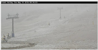
At present it doesn't appear that we are going to get much rain out of it, the BoM forecast having 5-10mm over the 4 days 10-13 May. It also seems very unlikely we'll get any snow, although its already falling at Perisher.
 Here is the Weatherzone Victoria radar at 0945 on 10 May. The red arrows show the approximate direction of movement on the current radar.
 The discussion of models on the Forum suggests the more productive element of the second front may go further North and whup the Central Tablelands rather than the Southern Tablelands.
The first front delivered 1mm of rain to Carwoola. Possibly better than nothing! The temperature plummeted as it passed over between noon and 1300 hrs.
 Just after 1600 hrs a weird little storm cell appeared heading right for us at the X.
 That dropped another 0.8mm on us.
Somewhat surprisingly at 1930 another serve appears to be heading in our direction. As the current outside temperature is +4.4o
C it's going to be rain not snow.
 By 0600 on 11 May we had scored 4mm of precipitation and the thermometer was 1.3
o
C. As the steps on to the deck were icy I suspect we had some sleet or such like earlier in the morning. At present our skies are clear but there is some serious precipitation happening in Victoria and possibly heading our way.
 The days maximum appears to have been 8.2
o
C. We've had no more precipitation and thus far the radar has shown the huge cell breaking up as soon as it gets to the Murray. Here is the image from Weatherzone at 1410.

Our overnight minimum by 1015 on 10 may was 4.9
C which is quite mild.
At present it doesn't appear that we are going to get much rain out of it, the BoM forecast having 5-10mm over the 4 days 10-13 May. It also seems very unlikely we'll get any snow, although its already falling at Perisher.


The first front delivered 1mm of rain to Carwoola. Possibly better than nothing! The temperature plummeted as it passed over between noon and 1300 hrs.


Somewhat surprisingly at 1930 another serve appears to be heading in our direction. As the current outside temperature is +4.4
C it's going to be rain not snow.

C. As the steps on to the deck were icy I suspect we had some sleet or such like earlier in the morning. At present our skies are clear but there is some serious precipitation happening in Victoria and possibly heading our way.

C. We've had no more precipitation and thus far the radar has shown the huge cell breaking up as soon as it gets to the Murray. Here is the image from Weatherzone at 1410.


Comments