The beach at Bastion Point
The shape of the beach accessed from the Bastion Point steps is very interesting, as it can change considerably due to conditions in the Inlet. Those who have seen the film "Skippy and the Intruders" filmed in Mallacoota in 1969. (Spoiler alert: Skippy is by far the best actor.) In the shots of the divers' boats going out the mouth is right down by the steps, which I have been told was the historical position. My informant - a long term resident - also explained that the position of the opening changed about 1km to the East following a period of closure when the dune was artificially cut at the point where the Inlet was closest to the ocean.
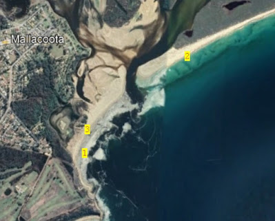
Point 1 in the image below is the historical opening and point 2 was the short cut opening. In the period since the short cut the position of the mouth, both 'natural' and forced, seems to have moved gradually westwards. The Google Earth image on which that is based is dated 2022 and I suggest was taken at a rather low tide. The mouth channel is about 110m wide in the narrowest point in that image.
We went for a stroll on 25 March. It was evident as we went down the steps that the beach was somewhat shorter than it has been!As we got round the bend of the beach - about point 3 in the first image - it was clear that further sand loss was occurring.
This next image shows the width of the mouth on that day (at close to high tide). Although hard to assess precisely I estimate it to be at least 250m wide. I have been told the channel is about 5 m deep (although much shallower than that a little offshore where a sand bar exists.)
Looking back into the Inlet, towards Captain Stevenson's Point, shows how the water has removed a lot of the dune, and the bushes thereon.
The next image is taken from the eBird track recorder showing
- where we walked (blue line);
- the area of beach that has been washed away (red line); and
- the isolated patch of samphire just visible in the previous image (green line);
The mouth is still very wide however.
A hew bird images to finish off. The first image shows 2 Bar-tailed Godwits, with one bird close to breeding plumage. It should probably be somewhere around the Yellow Sea in that colour!
The next two images are of an immature Pacific Gull. It flew across the sandbars and I found it again at the wharf where the photos were taken.
Even in this plumage the shape of the bill clearly says "Pacific Gull" rather than "Kelp Gull".


Comments